


London Tube Map
London Tube Map açıklaması
This application includes all London Tube/Underground lines, DLR, London Overground, TfL Rail and Trams. It combines an offline interactive map with a journey planner and a live status monitor.
Key features:
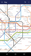
Offline Map: pan, pinch, search for stations and lines. Day Tube Map and Night Tube Maps are included.
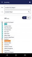
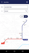
Offline Journey Planner: finds the fastest route to your destination using the specified service (day/night) and type of transport. Top London landmarks and touristic attractions are also included (London Eye, Big Ben, Tower of London etc).
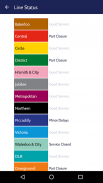
Line Status: checks the current status of the public transportation (requires Internet Connection).
Powered by TfL Open Data
Bu uygulama tüm Londra Metro / Metro hatlarını, DLR, Londra Yerüstü, TfL Demiryolu ve Tramvayları içerir. Çevrimdışı bir etkileşimli haritayı bir yolculuk planlayıcısı ve canlı durum izleyicisi ile birleştirir.
Anahtar özellikler:
Çevrimdışı Harita: pan, sıkıştır, istasyonları ve hatları ara. Gündüz Tüp Haritası ve Gece Tüp Haritaları dahildir.
Çevrimdışı Yolculuk Planlayıcısı: belirtilen servisi (gündüz / gece) ve taşıma türünü kullanarak hedefinize giden en hızlı rotayı bulur. Londra'nın en önemli simge yapıları ve turistik cazibe merkezleri de dahil edilmiştir (London Eye, Big Ben, Londra Kulesi vb.).
Hat Durumu: toplu taşıma araçlarının mevcut durumunu kontrol eder (İnternet Bağlantısı gerektirir).
TfL Açık Veri ile güçlendirilmiştir
London Tube Map - APK Bilgisi
APK sürümü: 1.05Paket: maplabs.londonLondon Tube Map uygulamasının en son sürümü
Diğer sürümler


Aynı kategorideki uygulamalar


Hoşuna gidebilecekler...


